⏺️
9 · REC — start your ride
The one button that matters. Tap it and PathXplorer starts recording everything — every second, every metric — until you tell it to stop. It keeps going with the screen off and the phone in your pocket.
Nothing else needs setting up first. Tap REC and ride; you can shape how it all looks afterward.

⏹️
10 · STOP — and it's saved
While you're recording, REC becomes STOP. Tap it and your track is closed and filed in your playlist automatically — no naming, no saving dialog, no chance to lose it.

⏸️
11 · PAUSE / RESUME — a break in the middle
The middle button changes with what you're doing. While recording it's PAUSE — for a long lunch you'd rather not have in your average speed. Paused, it becomes RESUME and picks the same track back up.

▶️Screenshot coming - the playlist
12 · PLAYLIST — every ride you've recorded
When you're not recording, that same middle button becomes  — and this is what it opens: every track you've ever recorded — the screen is titled Track List — ready to replay, rename, share or delete. The bar at the top searches them, merges two rides into one, and imports a .pathx track from another PathXplorer user. Pick one and watch it play back live, tiles and all.
Rides where you took pictures carry a 📷 count in their stats — and a green Photos button that opens that ride's own photo album, every shot pinned to the exact spot on the track where you took it. The album is also where you curate the ride: remove a picture from the track, or set how long each one holds on screen during playback and in your generated videos — the default you chose in step 3, adjustable photo by photo here.

▶️
During playback, the full-width Playback Slider sits above the dashboard — and every control on it is live:
Start flag & finish flag — the green dot and the checkered flag mark the ends of the replay. Drag either one to trim the ride down to just the part you want to watch.
The playhead — the green-ringed thumb is "now". Drag it anywhere in the ride and the map, the tiles and the photos all follow.
◀ ▶ — play the ride forward, or run it in reverse.
15s · 60s · 60× · 10× — the replay styles: 15s and 60s squeeze the whole ride into a clip of that exact length, 60× is a fast overview, and 10× is the opposite — a slow, maximum-zoom, turn-by-turn replay of every corner (free like the other three). The ✕ tucks the slider away.

📤Screenshot coming - the share dialog
13 · SHARE — turn a ride into something you can send
Tap  and a recording becomes a video, a photo, a PDF report, or a file of the raw ride. Choose what you want, and the app generates it and hands it to your phone's share sheet — Instagram, WhatsApp, email, anywhere.
Video — your ride replayed as an MP4, in four lengths. The two fixed formats show their exact clip length right under the label, for this ride:
15s and 60s — the whole ride squeezed into exactly fifteen seconds or one minute, whatever its real duration. The social-media formats.
60X — the ride at sixty times real speed: a fast flyover of the whole route, so a two-hour drive becomes about a two-minute film.
10X — the opposite of fast: ten times real speed at maximum zoom, the turn-by-turn replay that lingers on every corner.
Photo — a static image of the full track. PDF Report — the printable report of the next step. PathX File — the complete ride for another PathXplorer user (track, data and photos in one file). CSV File — the raw data. GPX File — the track for Garmin, Strava, Komoot and most GPS apps.
This is the button behind everything on this site: the videos, the reports, the shared tracks.
📄Coming soon - a PDF report
14 · The PDF report — your ride on one page
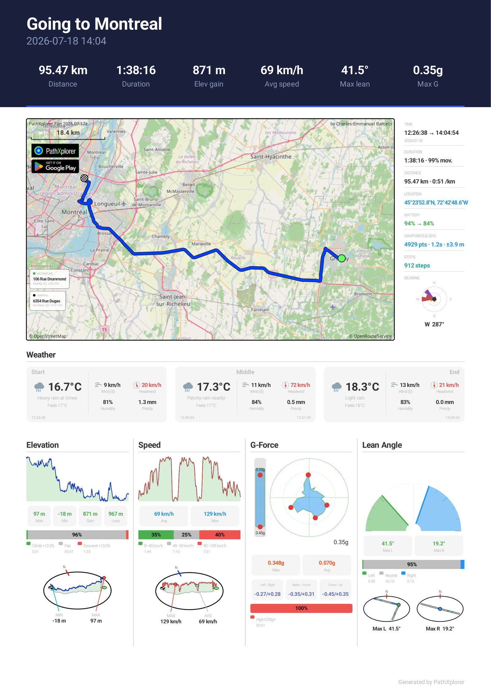
Pick PDF Report in the share sheet and PathXplorer lays your whole ride out on a single page: the route map with departure and arrival addresses, a side column of times, distance, coordinates, waypoint count and GPS accuracy, step count and bearing, the weather at start, middle and end — then elevation, speed, G-force and lean angle, each with its own graph, statistics and a 3D map of where it happened.
You choose which sections to include before exporting. Print it, archive it, or send it to anyone — it needs no app to read.
The report shown here is a real ride up Mont Royal in Montréal — exactly as the app produced it. Click it to open the full PDF.

📸
15 · PHOTO — pin what you saw
PHOTO appears while you're recording, and only then. Tap it, shoot, and the photo is pinned to the exact spot on your route — with the direction you were facing. It shows on the map, in playback, and drops into your video where you took it.

👥Screenshot coming - the group dialog
16 · GROUP — ride together, see each other
Tap  and pick a user name and a group name — no account, nothing to sign up for. Everyone in the group moves on your map, refreshed every minute, and a green dot on the button means you're sharing. While sharing is on, the map also carries a small blue tag in its corner: your group name and how many members are live right now. New to it? Join the group called world and watch explorers move around the planet.

🗺️
Map styles — pick your look
The bottom-left button cycles through the map styles — it always shows the name and colour of the NEXT style, so you know what's coming before you tap.

🏙️
2D / 3D — tilt the world
Right beside it, this button cycles the view: flat 2D, tilted 3D, and 3D+ with buildings rising from the map. It works live, in playback and in your videos.
Turn your phone sideways, too — the map takes the left of the screen and your full dashboard lines up on the right.




 at the top right of the map, then Permissions: every permission the app can use, with its current status in one place — one essential permission, precise location, and six optional ones: background location, activity recognition, notifications, camera, photos & files, and battery optimization. A last card opens your phone's own system settings. Each one explains what it unlocks — grant only what you need, when you need it.


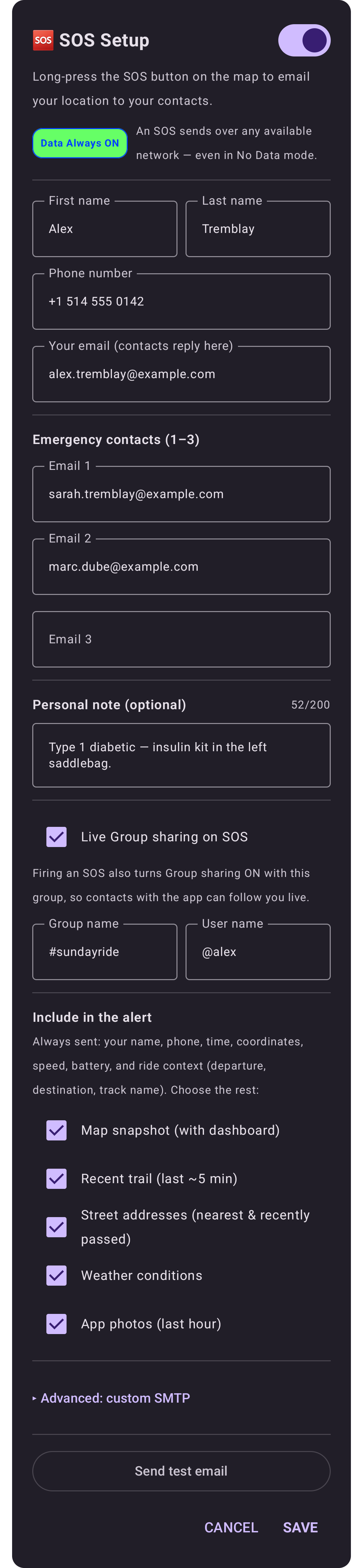
 appears on your map: hold it for three seconds and it emails your position to your contacts. Your name, phone, time, coordinates, speed and battery always go out; you choose the rest — map snapshot, recent trail, street addresses, weather, and the photos of the last hour. An SOS leaves over any available network, even in Zero Data mode. Do it once, then hope to never think about it again.